Colleague in Need – Atanas Entchev facing deportation

Update: The GIS community has come out in support of Atanas and his family. Calls for letters of support have spread across Twitter and has been picked up by several other blogs:

Despite this, the Entchev’s future in the US remains uncertain. If you have written a letter of support, thank you. Please write one if you are able.


Atanas Entchev, a familiar face to many on Twitter and throughout the GIS circles in the Northeast is currently facing deportation to Bulgaria. After emigrating here with his family over twenty years ago to escape political persecution, the US Government is now planning to deport the Entchevs. Atanas, his wife and his two children have been living in Central New Jersey and integrated into the local community. He has been involved with GIS in New Jersey for years, having worked in government at the Department of Environmental Protection and at several firms before starting Entchev GIS Architects back in 2005.

Last week, I received an email from Mayia, his wife, asking for letters of support as he is facing deportation. Mayia’s email is as follows:

I am writing you on behalf of my husband, Atanas Entchev, and our family. As you may know, Atanas and I emigrated to the U.S. from Bulgaria 20 years ago. Today, our immigration case is at a crossroads, and it is pertinent that we obtain letters of recommendation from the community. I am reaching out to you because you have been a colleague, client, or valued business contact of Atanas’. I am hoping you may be able to write a letter of recommendation for him. Time is of the essence, and it it crucial that we gather these letters as soon as possible, by today would be best.

If you are willing and able to write a letter of recommendation, your contribution will be invaluable to our case, and would be greatly appreciated by our family.
Please include your name, signature, address and phone number

Best would be if you can email the letters to:
mentcheva@hotmail.com & ericmarkesq@gmail.com
If not possible please fax to (201) 262-7640.

If you would like to get in touch with me, my contact information is listed below.

Thank you very much in advance, you help is greatly appreciated by our family.

Best,
Mayia Entcheva

I have known Atanas for several years now and I consider him a friend. While I knew he was not originally from here, I never thought of him as an immigrant. He is – in my mind – a fellow US citizen and outstanding professional colleague. He’s not a Bulgarian; he’s a New Jerseyan -  which is far different from what you see on TV.

If you have worked with Atanas, please take a few minutes to write a letter stating your support. These letters will be incredibly helpful to him and his family. Please send any letters to the email addresses or fax number above. If using email and if you have access to a scanner, they should be signed with your signature. I’m including below my letter of support for you to use as a guide. Continue reading

Posted in In the News, Meta, NJGeo.org | 9 Comments

RULost? I hope not.

Fellow Rutgers grad Jim Barry shared with me a link to a press release on the RULost iPhone app. While I was initially excited to see Rutgers come out with an app to aid students in navigating the huge New Brunswick campus (which is actually 5 campuses split between New Brunswick, Piscataway Township, Edison Township and a small portion in North Brunswick Township) and its extensive bus system, after plunking down 99¢, I’m not so impressed. Continue reading

Posted in Data, Mass Transit, Technology, Transportation, Web Mapping | Tagged , , , | 1 Comment

GIS & Live Maps for Hurricane Irene

New Jersey is in the path of Hurricane Irene. The last time a hurricane actually made landfall in New Jersey was the 1903 Vagabond Hurricane. The mandatory evacuations are underway (NJ OEM) and to my knowledge, it is the first time the Garden State Parkway has instituted contraflow traffic (NJTA, PDF). Below are links to several trackers and GIS resources to keep you up-to-date on the storm.

Posted in Data, In the News, Web Mapping | Tagged , , , | 1 Comment

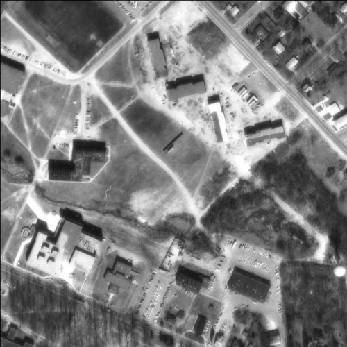
Statewide 1974 aerial imagery available via WMS

OIT has made the 1974 statewide aerial photography available via their WMS service.

WMS: http://njwebmap.state.nj.us/njimagery

Civil Solutions was the contractor that assembled the source imagery and prepared the seamless dataset for OIT.

The northeastern quadrant of Rowan's Glassboro Campus in 1974.

The northeastern quadrant of Rowan's Glassboro Campus in 1974.

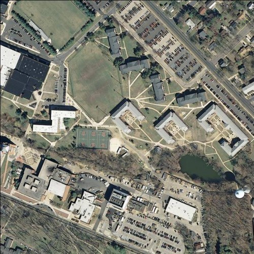
Same extent, but from the 2007 statewide imagery.

Same extent, but from the 2007 statewide imagery.

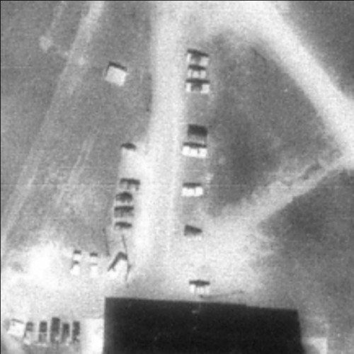
What I find amazing about the data is how clear the imagery is down to very large scale.

Detail of the parking lot north of Mimosa Hall

Detail of the parking lot north of Mimosa Hall.

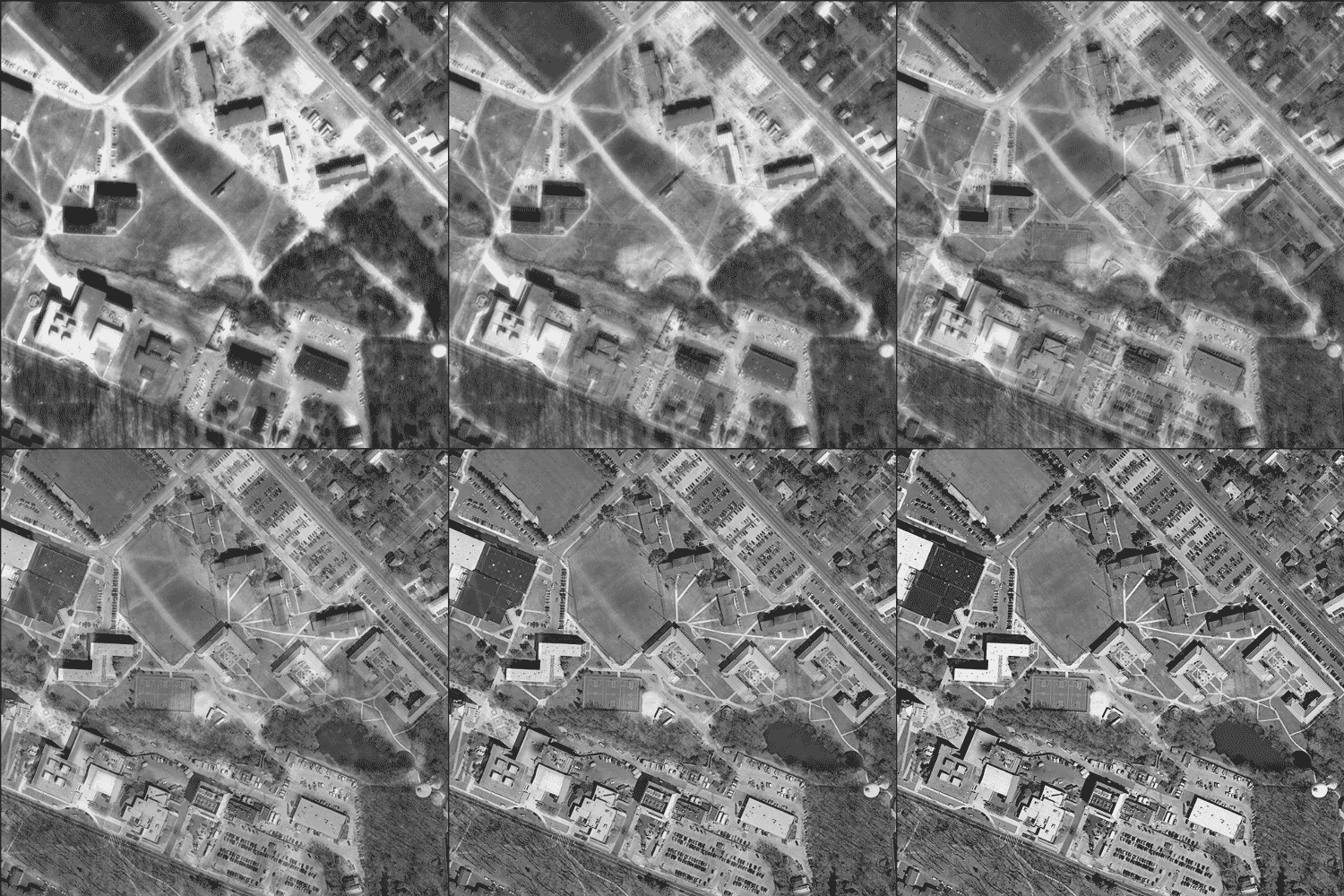
And just for fun, here’s an animation of the two images tweened, so you can see the amount of change on our campus in 33 years.

I checked EarthExplorer and there were several single aerial images from the 1950s of the area around our campus, but they aren’t georectafied and mosaicked. I may try to stitch them together so we could have images of the campus and ‘Boro from the 1930s, 1950s, 1970s and 1990s along with our more recent imagery.

Posted in Aerial Photography, Data, Government, Technology | Tagged , , , | 1 Comment

Map Maker for carto-masochists, part 2

After failing to provide data straight from GIS – which is possible using OpenStreetMap or ESRI’s Community Base Map programs – I sat down with Matt, my student intern that is working on developing the campus data in Map Maker. I instructed him to use our Facilites GIS database as a reference for populating the attributes for Map Maker and to have a polygon as a reference to supplement the Google aerial photograph. He began adding in features, but quickly ran into issues with the review process behind Google Map Maker edits.

Map Maker has a moderation process for all of the edits made by Map Maker users. There are two big issues I see with the manner in which Google has implemented moderation. First, you cannot re-edit (or even touch) new features until they have been moderated. That means that if you are adding a development (or a series of roads on a college campus) you cannot link up the roads that have been previously added and awaiting moderation. The moderation puts a serious crimp in attempts to push out many edits in a small area. Mike Dobson has an incredibly detailed write up on the issues he faced in trying to correct data using Google Map Maker. A very interesting read on how difficult it is to contribute minor fixes.

The second, bigger issue is the moderation itself. Crowdsourced moderation relies on people from potentially anywhere in the world to weigh in on edits. Now, it is likely that most of the edits occurring in the United States are being performed by individuals that are familiar with the area; they’re locals. Locals are the best source of information; they have intimate knowledge of the area and they are able to readily field-verify the information in the system. So we have a pool of local users making edits, but the moderators may not have any prior knowledge on an area in which they moderate.

Here’s a perfect example of the issue with this form of moderation. Google provides an attribute field for buildings that records the construction material. The field is restricted to an enumeration set of four allowable values: “Concrete”, “Mud/Stone”, “Steel” and “Wood”. Several of our campus buildings were held in moderation limbo, as a reviewer felt that my choice of “Steel” was incorrect and should instead be “Concrete.” Why would a reviewer feel the need to question an attribute and hold up the data creation process? Mind you, the values in this field does not impact the manner in which the building is displayed on the map, so it is not critical to know before the feature is drawn. What could a moderator glean from an aerial photograph that would justify questioning the local editor? I know the buildings are constructed using a steel structure and they are faced in brick and stone – I can walk up and touch the building; go inside. I spend hours inside these buildings each work day, but I need to provide a moderator elsewhere some justification or proof to have the edit approved.

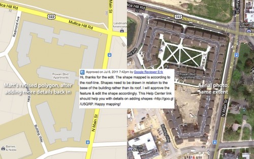
Matt drew in Rowan Boulevard Apartments, a building with a rather complex footprint, as the building has a series of setbacks dividing up the residential suites inside. He drew it in Map Maker as close as possible, similar to how it appears in OpenStreetMap. This edit was then altered and poorly generalized. The moderator informed Matt that it should not reflect the roof line. There are no stepbacks and the building is near the nadir of the photo, so the roof line is awfully close to the actual building footprint. He spent a considerable amount of time drawing in a feature to have it simply blown away by some one that likely has never been near the actual structure.

Compare the photo to what Matt was finally able to have approved.

The moderation system in Google Map Maker is broken and will continue to be if local users are not given the benefit of the doubt regarding their edits. OpenStreetMap has the ability to revert vandalism or poorly edited features. Know why people don’t vandalize OpenStreetMap? It’s often a pain in the ass to commit large amounts of vandalism on OSM. Unless you’re a programmer, committing large bogus edits to OSM isn’t easy to do. And on the occasions when vandalism occurs on OSM, it is often corrected by local users. Google’s fear of having bad data on Google Maps (even though so many errors pop up all the time through erroneous business entries scraped from search indexes) is hindering the ability of users to contribute to their platform. Google stole several concepts from OpenStreetMap but not the ones that can elevate it to a platform that could truly produce credible maps from locally-sourced volunteered data. The only thing going for Map Maker is that eventually your edits will appear on the main Google Maps site.

I got involved in Map Maker solely to get Rowan’s campus data on Google Maps. I cannot pull data back out of Map Maker, so after I achieve my goal, I will likely never use Map Maker again. Why deal with all the frustration and reap none of the rewards?

Update: Google Maps routes park visitors down a residential street that doesn’t actually provide access to the park, frustrating the local residents. Also, Google Maps Fail on Tumblr.

Posted in Data, Google, Google Maps, OpenStreetMap, Uncategorized, Web Mapping | Tagged , , | 1 Comment

Map Maker for carto-masochists, part 1

I originally wrote the following approximately two weeks ago and it has been lingering as a Draft until now. I decided to wait until the start of the Esri International User Conference to publish this post. The UC has several events planned for their community mapping offerings, here’s my take on how Google’s approach has been less than impressive. Part 2 to follow available here.

Way, way back in March of 2010, I contacted Google through their Map Content Partners form to submit Rowan University’s GIS data to be included on Google Maps. I heard nothing from them – not even an automated response – for several months. In August of 2010, someone in Administration noticed that Google had relabeled Rowan University as Glassboro State College, a name not used since 1992. I was instructed to try and remedy this as soon as possible. I explained that Google had given me the cold shoulder, but I would try some different avenues. The “report a problem” feature in Google Maps did get “Glassboro State College” off the map, but Rowan remained a featureless blotch within Glassboro.

After giving up on contributing data to Google Maps, I was finally contacted by “Brandon” from the Cities in 3D Team. Brandon requested a sample of the data for review. “Finally!” I thought, “now I can submit our data for Google Maps!” I’ll admit, I got excited. In hindsight, the excitement was premature and irrational. OpenStreetMap has been updated to reflect the campus since June of 2009, when I used my Export to OSM script to dump the facilities data into .osm files. I should be focusing my efforts on a custom, Mapnik-rendered set of OSM tiles that look good on top of aerials, a “Google Maps Hybrid” layer of my own. I can then sandwich in custom tiles instead of overlaying my data on top of the annotation. (Compare anno-on-top to data-on-top.)

Anyway, I eagerly await word back from Google that our data will appear on Google Maps. The notice I receive was far from what I wanted to hear. Instead of accepting the data, I’m instructed that due to the small number of objects to be added, I should use Google Map Maker instead. I was pissed.

I find Google Map Maker to be an incredible disappointment on two major fronts; first, I refused to use the service as I felt Google was in the wrong for keeping VGI-sourced base map data under lock and key. The second, which I will elaborate upon tomorrow, involves the Map Maker tool itself. For a company such as “do no evil” Google to create a framework where users can volunteer time to build its GIS repository with no compensation – not even data retrieval – I find completely unconscionable. Compare their data download form with getting data from OpenStreetMap. To non-techies, OSM’s XML format might be intimidating, but it’s data – no forms to fill out or licenses to sign. Sure, it’s not a shapefile… but you can get them too, without signing any agreement. I loved hearing how a group of OSM mappers hijacked a Google Mapping Party (the concept itself lifted from OSM) and got the assembled group to work on OSM. Many others have asked “why Google, why not OSM?” The common thread to most Map Maker criticism and OpenStreetMap’s major issue with Map Maker is regarding access to the data that has been contributed. Why make data created of the third world (and likely by individuals in the third world) a for-sale product for a first world company? Even within your own neighborhood, why volunteer your time if you can’t reap most of the benefits?

Back from ideology to practicality, I wanted the University on Google, solely because Google is the new Mapquest; it’s the go-to map service for the average person. (Quick aside, Mapquest has Rowan University completely mapped out through its OSM-sourced open.mapquest.com.) Brandon’s earlier suggestion of Map Maker wasn’t acceptable because of my open-access advocacy leanings, it was out of time constraints. “You want me to redraw everything?” That wasn’t going to happen and I let Brandon know:

Brandon,

Thanks for the info. My major concern has been getting an “official” set of data on to Google Maps. When Google switched to their own data and pulled place names from GNIS, Rowan University reverted to Glassboro State College, a name last used in 1992. As “the map guy” for the University, I was asked by several offices within Rowan to “fix Google.” While reporting the antiquated name as a problem did get “Rowan University” restored on Google Maps, it brought the lack of campus data on Google to the attention of many in the University community. It has been frustrating for me, as I have attempted to contact Google to provide official data for use on Maps for a considerable time, while also attempting to squash bugs in the Google Maps data on our campus. Being a University, there have been “creative” additions to the campus on Google Maps, such as the fact that one of our largest academic buildings appeared as a Bed and Breakfast for about a month.

I would like to provide Google with a set of data out of our Facilities GIS DB that is the same source for our printed campus maps. The previously sent data, reformatted to match your requested schema, is from either survey data or from a 3″ planimetric image. The address information included in this layer matches Gloucester County’s 911 data. This is as official as it gets.

Google Map Maker is not a viable option for me. The data for Rowan University that is available through OpenStreetMap  was generated through an export utility that I wrote. It is the same source as I emailed you previously, except that it dates from the summer of 2009. Very little of what is on OSM was hand redrawn. Not only would it be a considerable time sink for me, the tools in Map Maker would not be able to reproduce the high quality data that already exists.

Through the Geovisualization course I teach, we are offering students the opportunity to build SketchUp models of the campus as a final project. Several of the buildings have been completed and I will be uploading them soon. The entire campus is not complete, so if you would like a shapefile with extrusion data, I’d be happy to resubmit the data with those additional attributes.

Again, I would like to thank you for taking the time to respond to me. I understand that the Cities in 3D team might not have the 2D maps as their major focus, but if you could direct my request to the correct group, I would be incredibly grateful. I initially filled out the Data Provider form in March 2010 and have resubmitted the form several times after receiving no response. I even pestered Ed Parsons over Twitter to no avail. So, I am truly appreciative of your assistance in this issue.

Thanks,
John

Brandon responded with two points that made me bristle. First, Rowan was too small for Google: “the number of buildings on campus provide a relatively low priority for Google.” This is a 215 acre campus with 50+ structures, it’s not huge, but it’s also not insignificant. Second, I was encouraged “to do as much as you can on your own, or as part of
your class with the students help.” No one volunteers my cheap labor for projects other than me, buddy.

Through the reconfiguration of our program offerings, Geography and Environmental Studies students are required to have an internship or directed study as part of their capstone research experience. I was able to find a student that really excelled at contributing to OpenStreetMap and asked him if he would be interested in working on updating three map services: Google (via Map Maker), OpenStreetMap (via JOSM) and ESRI’s Community Base Map via (ArcInfo for Advanced Desktops). He agreed and began working on updating Google Maps. I finally bit the bullet, signed into Map Maker and started working with him on some of the edits.

Tomorrow, how Map Maker can only make bad maps.

Posted in Data, ESRI, Google, Google Maps, OpenStreetMap, Technology, Uncategorized, Web Mapping | Tagged , , | 5 Comments

ArcGIS: strong enough for Server, pH balanced for Desktop

James Fee pointed out how ArcGIS is undergoing minor rewording as part of the changes coming to the software at version 10.1.

Those were the good ol' days

One thing to note is that the ArcView license level is now Basic, while the ArcEditor level is Standard. While this brings ArcGIS (for) Desktop in line with the terminology used to describe current ArcGIS Server licensing (Basic, Standard, Advanced), something about ArcEditor being Standard strikes me odd. Perhaps it’s part of being in academia too long, but it seems like ArcEditor isn’t a big seller for ESRI. To me, those looking for the additional functionality over what is offered with ArcView would opt for ArcInfo, completely bypassing Editor. Also, we have (almost) always had ArcInfo licenses for the computer labs, while the Educational Time-out discs provided to students would have the ArcView level license. This two-level mentality must resonate with more people than just me. A recent change is that the last time I requested discs for ArcGIS 9 at the beginning of 2011, ESRI sent us 9.3 ArcEditor-level educational discs. And the ArcGIS 10 education discs I recently received are ArcInfo level. So is ArcView going to be phased out as the “entry-level” ArcGIS? And is ArcEditor ArcGIS for Desktop Standard going to see a decrease in price?

While I personally will miss the quirkiness of ESRI’s licensing terminology, I can see why it is being done. The progression of Basic, Standard, Advanced is clear while View, Editor, Info is not. Especially with the fact that some people are still using ArcView 3 (uninstall, already!) which is completely distinct from the ArcMap program in ArcGIS (for Desktop) 8.x and later.

What’s still unanswered for me is what happens to some of the other “ArcGIS” products. ArcPad? ArcGIS Explorer? ArcReader? They don’t get fancy new names?

Posted in ESRI, In the News | Tagged , , , , , | 2 Comments

Back to the New Normal

It’s been a while since I last posted to the ol’ Blog. After I returned from the DevSummit in March, my free time dwindled down to nothing. The end of the spring semester has been a whirlwind of activity; developing an online course, tackling several research projects, presenting at the National Guard’s CFMO University, and the usual end of the semester tasks like grading, projects, etc. Now that the semester is over and I’m a little more free to tackle projects, I hope that I’ll be able to blog some more about GIS in New Jersey. I’m still going to be busy; we have two faculty members to replace and even more students in our GIS courses, but I think summer will be a good time for me to refocus on programming and developing our GeoLab into a more robust research lab.

One interesting project that has popped up recently is NJ’s Broadband Map. You can dig through the data to find which areas of the State are served with broadband Internet. I think the color scheme needs to be rethought, as dark green to light purple is better suited to divergent or bimodal data, not to a linear progression of 1 to 8 broadband providers.

I’ll be at the ESRI DevMeetup tonight in Philadelphia, giving a lightning talk on the Land Change Viewer app I developed. Next week at the NJGF, I’ll give a 5 minute talk on the ArcGIS license monitor application I’m writing. I’ve got a couple other tidbits in the pipeline and hopefully I’ll be able to share them here in the next few weeks.

Posted in Technology, Tools and Scripts, Updates, Web Mapping | Tagged , , , | Comments Off on Back to the New Normal

Some thoughts on the ESRI DevSummit

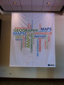
Geography Word Cloud BannerI’m back from the sixth ESRI DevSummit. It was a great event full of informative sessions, socializing and networking. This was one of the first conferences in a while where I did not participate more than simply attending. The DevSummit is truly for devoted developers and while I do some development, it’s nowhere near what I could call full time. Many of the user presentations were incredible displays of GIS geekery and I’m still in awe with what some people are doing with the software. Continue reading

Posted in Conferences, ESRI, Events, Technology | Tagged , , , , , , | 5 Comments

March Madness

Back in January, I had every intention of updating this weekly, but once the semester starts, all bets were off.

It’s been a crazy few weeks, juggling several research projects, two classes and compiling everything needed for my recontracting at Rowan. The last two weeks have been especially tasking; even without the occasional curve ball, I still lacked the hours in the day to get everything done. I need a break, but before that can occur, I need all the boxes checked on my to-do list. Tomorrow and Friday are going to be a blur of activity in attempt to get everything wrapped up by the week’s end.

Next week, I’m fortunate to be heading out to Palm Springs for the ESRI DevSummit. I’m really looking forward to learning more about the latest web mapping technologies. When it comes to server-side GIS, the Windows/.Net-based “ESRI Stack” is still a little foreign to me and it’ll be good to see how I could incorporate some ArcGIS-based technologies into my open source-based map services.

I’m also hoping to meet up with a few GIS folks I’ve followed on Twitter. While individuals at ESRI have been incredibly helpful with specific issues, I’ve found their online documentation to be lacking. There are several ESRI staff and third-party developers whose blog posts about an issue or a technology have clarified things for me and I’d like to let them know that in person.

Also, the DevSummit is the week before Spring Break. I’m not one to cancel class, so I’ve put materials online for my students and will likely Skype back in during class time. The question is, do I video call from my hotel room or do I conduct class poolside under a clear blue sky? Decisions, decisions.

Posted in Conferences, Events, Technology, Tools and Scripts, Web Mapping | Tagged , , , | 1 Comment