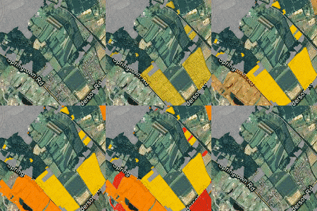
 John Hasse and Richard Lathrop have been studying land use change in New Jersey since 2002. Their previous reports have been the impetus of many discussions on urban sprawl, environmental protection and resource planning in New Jersey. The reports themselves were released shortly after NJ DEP released their updates to the statewide land use/land cover data. This data set covers 1986, 1995, 2002 and released just one month ago, 2007. Over the past month, I’ve been working on the report’s website, hosted at Rowan on our GIS server. The last month has literally been a blur as we’ve worked to get the data for the report together and then into a series of interactive, animated web maps that show the progression of urban change over 21 years. Over the next few days, I’ll be posting a series on the project, from inception through implementation to release. I feel proud at my accomplishment – within one month I managed to prepare all the data, render and store it on Amazon Web Services, and develop a simple framework for animating a tile-based web map. I hope to be able to detail the process so that others may be able to do the same. If you have not done so already, please check out the report’s website and leave feedback and questions in the comments below. I’ll try to answer any questions about the projects in the subsequent posts.
social networking
- Unless explicitly stated otherwise, the opinions expressed here are my own.
Tag Cloud
- Aerial Photography
- Apple
- ArcGIS
- ArcGIS Server
- Atlantic City
- Changing Landscapes
- Data
- ESRI
- Flickr
- geolab
- Geoserver
- geotagging
- GIS
- Google Earth
- Google Latitude
- Google Map Maker
- Google Maps
- Government
- gps
- Hurricane
- Land Use
- Location-based Services
- Microsoft
- new jersey
- New Jersey Geospatial Forum
- New Jersey State Atlas
- njgeo
- open source
- OpenStreetMap
- Planning
- postgis
- postgresql
- Privacy
- python
- Rowan University
- satellite
- social networking
- Teaching
- Updates
- Virtual Earth
- visualization
- Web Mapping
- wms

The LUC website is fascinating and addictive. Spent some time looking at Eagle Rock Park in West Orange.
Great job, John. I’m checking out the website now and can’t wait to find the updated “visual sequence” of expanding red-colored urban development.